SIGN UP FOR OUR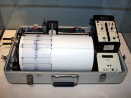
Source: Wikimedia Commons
On the morning of September 5th, 2012, residents of Guanacaste were going about their business and preparing to celebrate Costa Rica’s 191st anniversary of its independence from Spain when a powerful earthquake struck the Nicoya Peninsula. That seismic movement, which registered a magnitude of 7.6 on the Richter scale, is still producing aftershocks and striking fear in the hearts of locals and tourists more than a year later.
The latest aftershock occurred on November 9th, 2013. It was a quiet Saturday evening across the Nicoya Peninsula; fishermen were coming back from the ocean and surfers were preparing to leave the beach when an earthquake struck at precisely 6:30 p.m. According to geologists at the Volcanology and Seismology Observatory of Costa Rica (Spanish acronym: OVSICORI), this event made their seismographic oscillator needles jump to 4.3 on the Richter scale. The epicenter was located at about 3.5 kilometers southwest of Samara.
Within minutes of the seismic movement, the Facebook Timelines of OVSICORI and the National Seismology Network of the University of Costa Rica (Spanish initials: RSN-UCR) began to receive dozens of intensity reports from residents of Guanacaste who definitely felt the earth move under their feet. The depth of the earthquake was estimated at about 19 kilometers, and it was confirmed to have been of a tectonic nature, specifically caused by the geological process of subduction between the Cocos and Caribbean crustal plates.
Tectonic events caused by subduction essentially consist of the edge of a crustal plate moves sideways and downward into the mantle under another plate. Such was the Nicoya Earthquake of 2012, which geologists had been expecting for the Guanacaste region for quite some time. Although that earthquake was determined to have been the “Big One” for Guanacaste, it only managed to release 40 percent of the massive amount of seismic energy stored in the tectonic plates underneath Costa Rica.
There have been hundreds of aftershocks felt in Guanacaste since September 5th, 2012, and Mother Earth is not quite done yet; thus, residents and tourists from Playas del Coco up to La Cruz and down to Ballena Bay can reasonably expect to feel even more of these aftershocks in the months to come. To those who know that Costa Rica is a seismic and volcanic country, this should not come as a surprise.
UPDATE: A magnitude 3.5 earthquake was recorded by an RSN seismograph in Guanacaste this past Thursday. This seismic event was located 63 kilometers west of Cape Velas in Santa Cruz, at a depth of 7.3 kilometers, but it was not an aftershock of the Nicoya Earthquake.