SIGN UP FOR OUR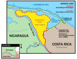
Wikimedia Commons
THE HAGUE, June 2016. The International Court of Justice (ICJ), the principal judicial organ of the United Nations, is to arrange for an expert opinion relating to the state of a portion of the Caribbean coast near the border between Costa Rica and Nicaragua, in the case concerning Delimitation in the Caribbean Sea and the Pacific Ocean (Costa Rica v. Nicaragua).
Longtime readers of The Costa Rica Star may remember that this case is essentially a continuation of the Google Maps Invasion of Costa Rica by Nicaragua in 2010, when Eden Pastora, an aging guerrilla fighter formerly known as Commander Zero, produced Google Maps printouts to justify the bivouac set up in Costa Rica by the armed Nicaraguan security forces who accompanied him on a dredging operation of the San Juan River.
When our Ministry of Foreign Affairs complained to Google, the search engine giant revealed that their mapping data on the region was obtained from the United States Department of State. All the same, it was incorrect information that Google quickly amended.
Notwithstanding the above, the case drags on; to wit: On 25 February 2014, the Republic of Costa Rica instituted proceedings against the Republic of Nicaragua with regard to a “[d]ispute concerning maritime delimitation in the Caribbean Sea and the Pacific Ocean”.
In its Application, Costa Rica requests the Court
“to determine the complete course of a single maritime boundary between all the maritime areas appertaining, respectively, to Costa Rica and to Nicaragua in the Caribbean Sea and in the Pacific Ocean, on the basis of international law”.
By an Order of 31 May 2016, the Court decided that:
“(1) An expert opinion shall be obtained, which will be entrusted to two independent experts appointed by Order of the President of the Court after hearing the Parties.
(2) The experts referred to in paragraph (1) above shall visit the site. They shall advise the Court regarding the state of the coast between the point suggested by Costa Rica and the point suggested by Nicaragua in their pleadings as the starting-point of the maritime boundary in the Caribbean Sea, and in particular answer the following questions:
(a) What are the geographical co-ordinates of the point at which the right bank of the San Juan River meets the sea at the low-water line?
(b) What are the geographical co-ordinates of the land point which most closely approximates to that identified by the first Alexander Award as the starting-point of
the land boundary?
(c) Is there a bank of sand or any maritime feature between the points referred to in subparagraphs (a) and (b) above? If so, what are their physical characteristics? In particular, are these features, or some of them, permanently above water, even at high tide? Is Los Portillos/Harbor Head Lagoon separated from the sea?
(d)To what extent is it possible, or probable, that the area concerned will undergo major physical changes in the short and long term?